Afternoon Showers and Thunderstorms Likely Across Indiana
Afternoon Showers and Thunderstorms Likely Across Indiana for Saturday
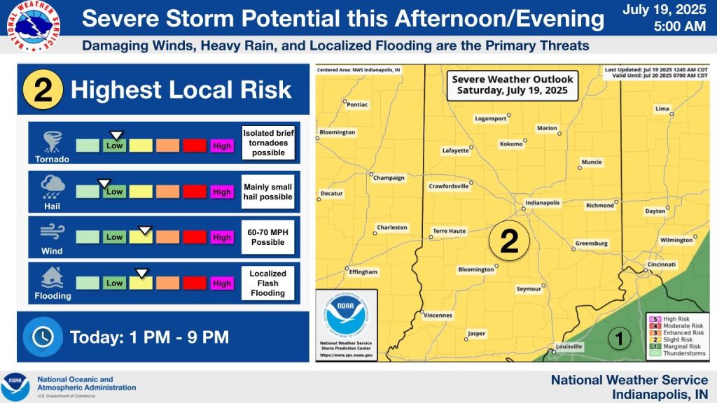
INDIANAPOLIS — There’s a chance of strong to severe storms for Saturday afternoon and evening across Indiana.
The day starts off dry with fog in some spots, but thunderstorm chances are likely starting in the early afternoon hours. Meteorologist Joseph Nield with the National Weather Service in Indianapolis said central Indiana will be hit the hardest sometime after 2 p.m.
“We continue to expect a threat for severe storms primarily in the afternoon and into the evening hours,” Nield told WIBC. “The most likely time in the Indy metro area is around 3 to 7.”
Thunderstorm chances will pick up and they will bring heavy rain and strong winds. Damaging winds are seen as the primary threat.
“Any thunderstorm in this atmosphere as saturated as it is has is going to have a threat for heavy rain and localized flooding, particularly in areas that have already seen rain in the last several days,” said Nield.
There’s another weather possibility that Nield said is possible too.
“Can’t rule out an isolated, brief tornado of course,” he said.
Showers will linger into Saturday night with more storms possible. The severe threat will go down, but flooding remains a concern.
The high for Saturday will be in the mid-80s. Low temperatures will be in the mid-70s.
As for Sunday, high temperatures will be in the mid-80s, but scattered showers and storms are expected, mainly in the afternoon and evening hours again.
“There will be a threat for isolated, severe storms on Sunday as well,” Nield said. Basically, from central Indiana southward and the primary threats of that will be damaging winds and heavy rain to localized flooding.”
Multiple inches of rain could fall in some spots south of I-70 this weekend.